Why the olive grove path
Members of the Spoleto Club Alpino wanted to
share their knowledge of this area dominated by
olive groves that characterizes an extensive
part of the Umbria Region.In the beginning
stages, the report contained only the area near
Spoleto Trevi. Successively the project was
extended to include the collaboration of the
Foligno Club Alpino and the Assisi Club Alpino.
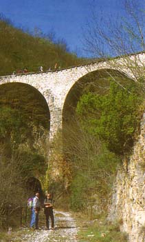
It is a particularly interesting course that
gives evidence of just how important the olive
groves have always been for the Region. There
are many reminders of works carried out in the
past by the skillfull farmers. Today, because of
the high price of labor, these type of works are
no longer executed, especially upon pieces of
abandoned land. The absence of these olive
terraces and lunettes are causing serious
hydrogeological and visual damages.
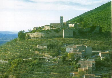
 The
suggested itinerary touches upon a series of
urban installations of small dimensions that in
Roman times, were developed in order to escape
the progressive reversion of the plains into
marshland. These installations, or castles, are
in fairly good conservation. The Castles in
central Italian culture and in Umbria in
particular, were not only the residence of the
squire. They served as the first urban centers .
Usually these consisted of some ten or so houses,
each up against the other, surrounded by a high
walled fence as a means of protection for its
residents and their various activities.
The
suggested itinerary touches upon a series of
urban installations of small dimensions that in
Roman times, were developed in order to escape
the progressive reversion of the plains into
marshland. These installations, or castles, are
in fairly good conservation. The Castles in
central Italian culture and in Umbria in
particular, were not only the residence of the
squire. They served as the first urban centers .
Usually these consisted of some ten or so houses,
each up against the other, surrounded by a high
walled fence as a means of protection for its
residents and their various activities.
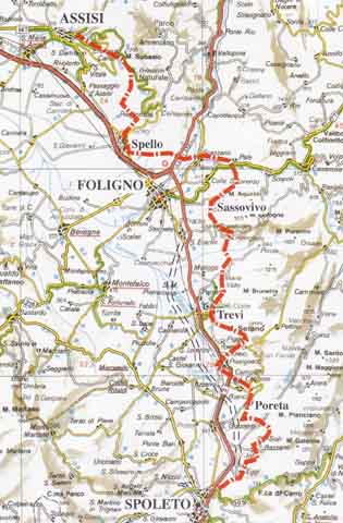
Each excursion stage and its difficulty
The total length
of the itinerary is about 75km. It unwinds for
the most part between 350 and 700 meters in
altitude and is subdivided into 5 stages:
SPOLETO-PORETA / PORETA-TREVI / TREVI-SASSOVIVO
/ SASSOVIVO-SPELLO / SPELLO-ASSISI. Each stage
is posted with its level of difficulty by an
official CAI “E” (Club Alpino Italiano) sign:
Itineraries that are carried out on paths and
are for hikers m a certain level and training.
The majority of the itineraries are along paths
and travel ro ads(occasionaly with short tracts
of asphalt) and with uphill slopes of no more
than 1000 meters. The only really difficult one
(only because of it being slippery when wet) is
near Eggi. In this particular tract a 30 meters
cord has been constructed permitting hikers to
descend or ascend safely.
Which way and how long
 The
paths can be taken in either direction but it is
preferable to begin the hike from the south,
heading towards the north, in other words,
departing from Spoleto, heading towards Assisi.
Not only is it a more interesting panorama, but
by walking in this direction the sun is always
at our backs, facilitating any photographic
documentation.
The
paths can be taken in either direction but it is
preferable to begin the hike from the south,
heading towards the north, in other words,
departing from Spoleto, heading towards Assisi.
Not only is it a more interesting panorama, but
by walking in this direction the sun is always
at our backs, facilitating any photographic
documentation.
In the descriptions of each path, there are
indications referring to the amount ()t time
needed for each tract and total time needed,
including rest stops, for the entire itinerary.
Take into consideration an average hiker who
covers about 3 km per hour and a 300 meter
ascent and a 450 - 500 meter descent.
Train and road connections
The entire course runs along the east side of
the Flaminia highway (at this date undergoing
the final stages of restructuring between
Spoleto and Foligno) and the train line
Rome-Ancona which leads to Foligno, and the line
Foligno-Terontola which goes towards the Assisi
station.
Hikers can personalize their trip by using the
train in order to return to the starting point
at the end of the day.
Information regarding train schedules and the
availability of special trains equipped for
bicycle transport, is available at the various
stations.
How and when to plan your hike
 Any
of the paths can be traveled throughout the year
on foot or by mountain-bike, and there are
others where horses can be ridden. It should be
noted that during the summer, it is best to
begin quite early in the morning and to take a
long break during the hotter hours of the
afternoon. During the period between November -
March , in the stretch between Spello - Assisi,
it is quite possible to encounter fog. It is
easy to find water due to the presence of
natural springs, but it is always a good idea
bring along a liter of water.
Any
of the paths can be traveled throughout the year
on foot or by mountain-bike, and there are
others where horses can be ridden. It should be
noted that during the summer, it is best to
begin quite early in the morning and to take a
long break during the hotter hours of the
afternoon. During the period between November -
March , in the stretch between Spello - Assisi,
it is quite possible to encounter fog. It is
easy to find water due to the presence of
natural springs, but it is always a good idea
bring along a liter of water.
Road signs
 The
two clubs are completing a series of small red/white/red
flag signals and a series of red signals, which
indicate the various paths. The flags, have been
painted on tree trunks, rocks, walls and
wherever they might be visible to hikers
traveling in both directions.
The
two clubs are completing a series of small red/white/red
flag signals and a series of red signals, which
indicate the various paths. The flags, have been
painted on tree trunks, rocks, walls and
wherever they might be visible to hikers
traveling in both directions.
Attention must be given to always follow
carefully the indications given along the path
and to take along a topographical map as it can
occur that these small road signs can become
damaged over time.
At this time, from Spoleto to Spello, the red
and white flag signs carry the insignia S.U.
which stands for Sentiero Ulivi (Olive Grove
Path).
In the area of Monte Subasio along the stretch
Spello-Assisi, we find path n. 50, and along the
variant Fonte Bregno-Rif. Vallonica, path n. 60.
General information
Club Alpino
Italiano in Spoleto,
Piazzale Polvani, 08 tel/fax +39 0743 220433
infocai@caispoleto.it
[for
more informations about the maps with details
(1: 25.000) of the"Franciscan Itinerary "contact
us]

.JPG)
